

Monitoring New Hampshire’s Aquatic Ecosystems: Continuous Data Collection in the Lamprey River Watershed
New Hampshire’s aquatic ecosystems provide a range of ecosystem services to the state and region. Resources and services like clean water, carbon storage, climate regulation, nutrient regulation, and opportunities for recreation all depend on New Hampshire’s aquatic ecosystems remaining healthy.
Jody Potter, an analytical instrumentation scientist at the University of New Hampshire (UNH), is studying these aquatic ecosystems in hopes of developing an improved understanding of ecosystem services and their interactions with climate change, climate variability, and land use changes.
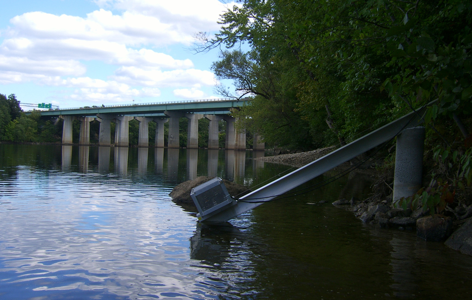
Aquatic sensors in the Merrimack River in Bedford, NH, with I-293 in the background. (Credit: Jody Potter / University of New Hampshire)
Monitoring New Hampshire’s Aquatic Ecosystems
Efforts to define conditions in the region date back several decades, an example of which is the Lamprey River Hydrologic Observatory (LRHO), which was established in 1999 by Professor William McDowell when grab sampling in the Lamprey River was initiated.
The LRHO is currently spearheaded by Professor Adam Wymore, Director of the UNH Water Quality Analysis Lab (WQAL) and NH Water Resources Research Center (WRRC).
According to Potter, the now 26-year dataset offers an early look at “the effects of suburbanization and changing seasonality on watershed hydrology, biogeochemistry, and nutrient export to an estuarine ecosystem.”
In 2012, the National Science Foundation’s Established Program to Stimulate Competitive Research invested in the LRHO, aiding in the expansion and continued operation of an aquatic sensor network.
The aquatic sensor array was deployed by UNH WQAL “to better understand complex interactions among climate, land use, aquatic ecosystem function and services, and society,” according to Potter.

Aquatic sensors in Albany Brook at Bartlett Experimental Forest (administered by the USDA Forest Service Northern Research Station) with Jody Potter looking on. (Credit: Lisle Snyder / University of New Hampshire)
The data from this network will go on to contribute to a larger understanding of the biogeochemistry of New Hampshire’s watersheds, quantifying the exports of organic matter, sediments, and nitrogen to downstream ecosystems.
“In our area of New Hampshire, the Great Bay estuary is of ecological concern due to declining eelgrass and water quality. We are contributing to the understanding of the causes of those declines,” explains Potter.
The WQAL is one of the few sensor networks that is operated year-round, including under ice cover in winter. Driving questions for the lab include:
- How does variability in concentrations of solutes change with high-frequency data records?
- How do nutrient flux estimates vary between high-frequency and lower-frequency sampling protocols?
- How do concentration-discharge relationships vary over space and time?
- What is the contribution of storm events to annual solute export?

Aquatic sensors at Hubbard Brook Experimental Forest Weir 3 – administered by the USDA Forest Service Northern Research Station, where watershed studies were pioneered in the 1950s. (Credit: Lisle Snyder / University of New Hampshire)
Evolution of the WQAL’s Sensor Network
For the first ten years of the WQAL network, there were ten stations that collected data in the state’s three main watersheds (Merrimack River, Saco River, and Lamprey River). However, there are currently only four stations operating in the Lamprey River watershed due to funding restrictions.
Instrumentation of the current WQAL stations have changed over time, with sensor selection depending on the location and data needs for the area.
Stations are currently equipped with a YSI EXO2 measuring dissolved oxygen, pH, turbidity, fluorescent dissolved organic matter, conductivity, and temperature; Onset HOBO water depth transducers; cell modems for telemetry; and a data logger.
Two of the stations include a Seabird SUNA nitrate sensor, one includes a TriOS OPUS UV Spectral Sensor, and the final station is equipped with a S::can spectro::lyser V3 Spectrometer Probe.

Aquatic sensors in a tributary to Back Creek at Dowst Cate Town Forest in Deerfield NH – an example of impacts of drought potentially from climate change, as stream dries up with sensors exposed. (Credit: Lisle Snyder / University of New Hampshire)
Public-Facing Data for a Community Dedicated to Conservation
Data from the network is quality checked by Potter, analyzed by the lab, and then published in scientific journals as well as to the general public. This public-facing data aspect is of particular importance to the lab’s work.
The region has a strong history of protecting its natural resources and preserving the land, something that has been particularly rewarding to engage with, according to Potter.
He explains, “The importance of our work to the community that is concerned about the health of Great Bay and other New Hampshire aquatic ecosystems is very rewarding. I also thoroughly enjoy interacting with young people that also have concerns about aquatic ecosystem health and have great enthusiasm for science.”

Aquatic sensors at Hubbard Brook Experimental Forest Weir 9 – administered by the USDA Forest Service Northern Research Station where watershed studies were pioneered in the 1950s. (Credit: Lisle Snyder / University of New Hampshire)



0 comments